Friday, May 17, 2019

Old City Hall: When I.M. Pei came to Binghamton, NY (1965)

Architect I. M. Pei (1917-2019)
at Louvre Pyramid (1989), Paris, France. 


I.M. Pei, the celebrated architect, died yesterday. It is a great loss to everyone who has delighted in his elegant creations. Architectural critic Paul Goldberger’s obituary for Pei (New York Times 5/16/2019) describes not only the impact of his work, but Pei’s immense humanity, and his belief that:

Architecture can reach a level where it influences people to want to do something more with their lives. That is the challenge that I find most interesting. - I.M. Pei

Until three years ago, I had no inkling that this internationally-known artist of stone and glass and light had ever touched my gritty industrial hometown in upstate New York.  But, while researching in the vertical files at the Broome County library for the history of  Binghamton's “Old City Hall,” I discovered that in 1965 Mr. Pei was a contender for the design of an addition to the historic building. Here is that story:


“Old City Hall” - A Beaux Arts Delicacy in Downtown Binghamton


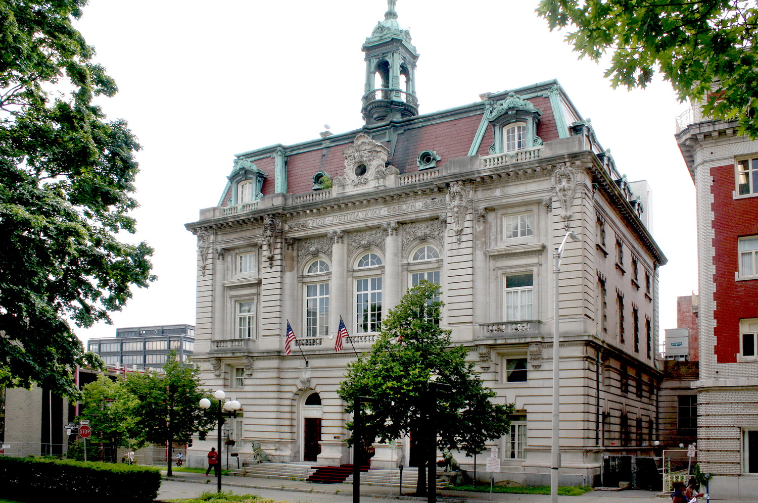
Old City Hall, Binghamton, NY
(1898, Raymond Francis Almirall, Arch.)
Binghamton’s 1898 City Hall reflects, perhaps more than any other building, the story of development and redevelopment in that city over 120 years: from the founding of the first settlement; through growth and prosperity; then decline and abandonment; and finally its redevelopment, albeit not a full rebirth. It is a story reflected in the varying fortunes of Binghamton City Hall.

Binghamton was founded at the confluence of two great rivers of the Southern Tier:  the Chenango and the mighty Susquehanna. The favorable siting encouraged its growth as a regional distribution center for locally produced goods. The opening of the Chenango Canal in 1837 and the arrival of the Erie Railroad in 1848 spurred even greater development of local industry. After the Civil War, Binghamton became a booming manufacturing center, fostering great wealth and fine residences for its industrialists, leading to its nickname “The Parlor City.”

In 1857, Binghamton built its first city hall on Collier Street, just across from the Broome County Courthouse constructed on the Court Street green one year earlier. Unlike the simple classicism of its neighbor, the City Hall was a homely, practical building that also housed the fire department, the police station, and community gatherings. Eventually, the violent ringing of the fire bell weakened the tower, so the residents sought to build a new city hall and move the fire department elsewhere.


Original City Hall and Fire Station (ca. 1860). 

When voters finally approved the new city hall in 1895, Binghamton was prosperous. The City wanted a much more imposing home for its government and launched a national  competition for its design.  The two submissions known to date were those of Raymond Francis Almirall (1869 – 1939), then finishing up four years of study at the École des Beaux-Arts, Paris; and Henry J. Ross, a young architect working with the firm of Henry L. Ottenheimer in Chicago.

The two designs couldn’t have been more different. Almirall’s was a full-blown French Second Empire “Hotel de Ville” (city hall) – a monumental, effusive, 5-story building of native sandstone and brick, with rusticated base, tri-partite entry, filigreed wrought iron gates; scrolls; cartouches; swags; balconettes; and some rather chubby putti lounging on the façade’s clock. It was exceedingly formal - symmetrical in plan and elevation, and capped with an ornate, open lantern cupola. Mr. Ross’s design, in contrast, showed both the influence of Adler and Sullivan and H. H. Richardson’s Romanesque, e.g., an inset main entrance hooded by a broad round arch, asymmetrical form, and Sullivanesque encrustation of the tower, among other things.

Main Staircase of hotel 
(former Old City Hall) in 2016.
Main Dining Room of hotel
(former Old City Hall) in 2016.


By 1896, the design world had experienced a dramatic shift: Richardson was dead; an economic downturn badly affected Adler and Sullivan’s prominent practice; and America became  enamored  with the 1893 World’s Columbian Exhibition, where the “City Beautiful” was dominated by Classical architecture and Beaux Arts arrangements for the urban plan. Almirall’s City Hall design won the day. The architect later refined his design, resulting in an even more elaborate building as realized.

 In December 1896, as construction had commenced on the Almirall design, the 1856 courthouse was destroyed by fire. It became a perfect opportunity to create a well-designed civic space, centered on a new, monumental courthouse surrounded by a large green. This new courthouse was constructed in 1897-1898, around the same time that the new Binghamton City Hall opened for business.

Several more Beaux Arts or Classical style buildings were constructed around courthouse square over the next 15 years. Together they make a pleasing assemblage of buildings, each fittingly formal, that provides a coordinated backdrop for the courthouse.  The Courthouse and commercial buildings around the square are still in use; the Old City Hall, however, endured a perilous journey to its ultimate preservation.

Binghamton’s Era of Urban Renewal and Redevelopment


Binghamton began a massive urban renewal campaign in the late 1950s. The region had weathered the Great Depression well enough, thanks to a strong economic base, but the post-war period brought losses in industries, in personal and business income, and in population. Binghamton, like many forlorn cities of that period, was confronted with empty storefronts and a declining tax base. It sought redemption and rebirth through urban clearance and redevelopment.


Government Plaza (postcard), ca. 1975. 

Redevelopment efforts began in 1957. More urban renewal plans followed, including the creation of a “Government Plaza” south of the existing Courthouse square. It would house both state and county office buildings and perhaps a new, larger home for the then woefully inadequate City Hall. Prevailing chatter at the time noted that renovation of the existing building would be “too expensive.”


Action-Reaction: The Quest for Preservation


In 1964, the Commission on Architecture and Urban Design (CAUD) was created to guide urban renewal efforts, and to identify buildings worthy of preservation. That same year came the first call to demolish the old City Hall, with its faded and well-worn beauty, setting off great angst among those who felt it should be preserved. 

Then-outgoing Mayor John Burns wanted to preserve old City Hall. In September 1965, he vetoed an ordinance that called for the city to move its offices to the new Plaza. Two months later, Mayor Burns invited I. M. Pei to tour the proposed site, the goal being a site study for an addition to the existing City Hall, as an alternative to abandoning it for a new building.

Around the same time, Pei, who had formed his own firm I. M. Pei & Associates in 1955, was designing in partnership with developer William Zeckendorf’s firm Webb & Knapp. Among the designs he was completing at this time, included the severe Kips Bay Plaza in New York, finished in 1963; the Brutalist Society Hill Towers in Philadelphia (1964); and Silver Towers (University Village) near Washington Square in New York City (1967) – all gridded works in concrete. 

Pei was also working on his own more creative projects, which included the National Center for Atmospheric Research in Boulder, Colo., completed in 1967, and the Everson Museum of Art in Syracuse as well as the Des Moines Art Center, both finished in 1968. These creative projects were also executed in concrete, although in softer colors of rose and buff and arranged in large, geometric, and generally windowless masses.

Pei’s thoughts on wholesale redevelopment and renewal are a topic for a separate, more intense study. However, in an article on urban renewal published the month after his visit to Binghamton, Pei noted that “If you drove all the residents out and made [the city] a gleaming commercial center, it would only be beautiful in a narrow sense. It would be lifeless, and therefore intolerable” (Life Magazine 12/29/1965:139). Perhaps it was this notion of bringing life to the city that drove him to the surprising and elegant design for the Louvre Pyramid in Paris (1989), where the historic Beaux Arts building was reflected in every surface of the crystalline prism. 

For Binghamton, it seemed, Pei hoped to create a similar dialogue between the old City Hall and an adjacent contemporary addition, rather than adding to what was the rather barren landscape of what was becoming the new “Government Plaza” on a nearby parcel. It is a matter of great pride to those who remember this series of events that Pei not only found merit in Binghamton's historic City Hall, but also found it worthy enough to incorporate his own design that would ensure its future use and artful contribution to the streetscape. 

After Pei had studied the proposed sites for the new City Hall at Binghamton, he insisted that he would only take on the study 1) if he were to be acceptable to the incoming administration, and 2) if the addition could be placed next to the existing building, on the site of the newly constructed – and as yet unpaid for - parking deck. 


Old City Hall and Parking Garage (foreground), Collier Street, Binghamton (2016).

Although the Burns administration had approved retaining Pei for the site survey in the last weeks of its tenure, the incoming administration was not interested. It did not want anything built but a brand new building on Government Plaza. Both of Pei's conditions having been defeated, he did not return to Binghamton. 

The New York State Office Building, the centerpiece of the plaza, was completed in 1966; it was followed by the county office building and finally the new city hall, on the western half of the site.

The City government vacated “Old City Hall” in 1972 for the graceless and forgettable new City Hall building at Government Plaza. Anticipating this, local preservationists had the historic building listed on the National Register of Historic Places (1971) and recorded by HABS (1972).

The building sat empty for 10 years as three separate adaptive use proposals were floated. Two failed, but a third proposal succeeded. Local developer Frank Cosentino’s proposal for a hotel and conference center utilized some $500,000 of state and federal grants, which required the restoration of the exterior, the lobby and the former council chambers. The building has remained a 55-room hotel since 1983 and was known as “The Grand Royale Hotel” (the hotel is now known as the "Nuru Binghamton Downtown"). The main entrance was removed to the non-descript rear façade of the building, where cars could park during check-in.


New main entrance of the hotel on State Street, Binghamton, NY in 2016. 

The parking deck next door was demolished in 2016; it was anticipated that an 8-story mixed-use retail and parking facility would be built in its place, but, as of this writing, there is only a surface parking lot.


Postscript and Regrets


Today, if you run an Internet image search for “new City Hall Binghamton,” 99% of the results are of the Old City Hall. Only a few photos of the new city hall could be found in the search. The Old City Hall is still a venerable presence on the streetscape, as is the Main Public Library and the Beaux Arts Courthouse. It is refreshing to be rid of the rusting ca. 1960s parking deck that blocked the view of the historic City Hall. But, just think, for one hopeful moment in 1965, Binghamton could have become the beneficiary of an original design by the great I. M. Pei, architect to the world. And now he is gone.


Resources:


Chen, Aric. “A tribute to I.M. Pei, a disarming and determined visionary.” CNN Style, on CNN.com, the official website of Cable News Network, Inc. ("CNN"). (17 May 2019) URL: https://www.cnn.com/style/article/architect-im-pei-legacy/index.html  accessed 5/17/2019. 

Dragos, Stephen, Ex. Dir., Valley Development Fdn. and John Poppeliers, Sr. Ed., HABS.  “Binghamton City Hall, Collier Street, Binghamton, Broome County, NY. Photographs, Plans, and Data Sheets. HABS No. NY-5568, HABS-NY, 4-Bing, 3. Historic American Buildings Survey. Washington DC: National Park Service, U.S. Department of the Interior, 1972.  From the online collections of the Library of Congress, American Memory, URL http://www.loc.gov/pictures/item/ny0457/ accessed August 2016.

Goldberger, Paul. “I.M. Pei, Master Architect Whose Buildings Dazzled the World, Dies at 102.” New York Times (16 May 2019). URL: https://www.nytimes.com/2019/05/16/obituaries/im-pei-dead.html  accessed 5/17/2019. 

"I.M. Pei: Buildings & Philosophy.” Chapter 10, Lesson 6. “Famous Architects Study Guide.” Study.com website. URL: https://study.com/academy/lesson/im-pei-buildings-philosophy.html accessed 5/17/19.

Peckham, Mark L., Field Services, NYS Office of Parks Recreation and historic Preservation, Preparer. “Court Street Historic District.” Nomination to the National Register of Historic Places. Listed on the National Register 09/07/1984 and NYS Register (08/03/1984). From the online collections of the NYS Cultural Resource Information Systems (CRIS). URL https://cris.parks.ny.gov/ accessed August 2016.

“R. F. Almirall, 69, Architect, Is Dead.” New York Times. 19 May 1939. Online NYT archives. URL https://timesmachine.nytimes.com/timesmachine/1939/05/19/93914239.html?pageNumber=27 accessed August 2019.

Waite, Diana, Preparer. “Binghamton City Hall.” Nomination to the National Register of Historic Places. Listed on the National Register (03/18/1971) and New York State Register (06/23/1980). From the online collections of the NYS Cultural Resource Information Systems (CRIS). URL https://cris.parks.ny.gov/ accessed August 2016.

Withey, Henry F., AIA, and Elsie Rathburn Withey, Biographical Dictionary of American Architects (Deceased). Los Angeles: Hennessey & Ingalls, Inc., 1970.

Local history collections of the Broome County Library, Binghamton, NY (vertical files).


Friday, February 22, 2019

Case Study: Redevelopment Zones and their Impacts on Historic Properties, Montclair, NJ (1998-2018)


This study considers ten redevelopment plans in a single town in New Jersey, which created some 1500 new multi-family units and rehabilitated some 29 deteriorated residential buildings in the Township over the course of 20 years.


The study was sponsored by the Montclair Historic Preservation Commission. It (and the substantial number of redevelopment projects currently underway) generated several news articles in the regional press.


Jaimie Julia Winters, "Ten Developments, 20 Years: Report looks at What Worked, What Hasn't," Montclair Local (January 31, 2019). 

Julia Martin, "Rapid development poses risks for Montclair," North Jersey Record (February 21, 2019; updated February 22, 2019). 

Montclair's downtown is awash in new construction, much to the inconvenience of the residents. One major street has been closed for some three years for the construction of an 8-story hotel with no end in sight, and more recently, two blocks around a major entertainment venue have been closed off, the lots cleared, and two parking lots nearby are fenced off to create a new "arts district." The disruption of normal life downtown had resulted in pushback from the residents on several other projects that add even more density to the area. 

How do we decide whether a redevelopment project is worthy of pursuing? What are the costs? What are the benefits?


You can find the full study here.

Friday, January 31, 2014

Fracking Paradise - The Catskills on Hold

Life is on hold in the region of the Marcellus Shale, in upstate
New York and Pennsylvania.

I fell in love last week. It lasted five whole days. It was magical. But, like many love affairs, it ended with sighs and regrets.

The object of my affection was a hand-hewn log cabin, overlooking a farm in the Western Catskills. The craftsmanship was delicious, the spaces eccentric but homey, and the vista across the valley was breathtaking. I was ready to pack my bags, forsaking all others.

Such a weak-in-the knees affair is an occupational hazard, I suppose, for anyone in historic preservation. A spare computer moment may easily turn into an hour wandering through real estate websites looking at historic houses. Not that I am actually thinking of moving from my home base in Northern New Jersey. I like to think of it as “market research.”

Admittedly, the thought of a house on a hill somewhere has gained traction after a year spent repairing the Ocean City cottage after Super Storm Sandy. My next retreat would definitely be somewhere outside a floodplain, and ideally not more than two hours from home. That’s turning out to be more challenging than I thought.

Being a native of upstate New York, I remember the region as astoundingly beautiful, traversed by the rivers and streams, with misty hills and fertile farmland dotted with cows. In spite of – perhaps because of – a decades-long economic recession, much of it remains unspoiled, especially in the Catskill Mountains about two hours northwest of New York City. It was here I started to look for my house on a hill.

Hills in Catskill Mountains near Margaretville, NY

In normal times, one could expect to find some reasonably priced and relatively intact country properties idealized by New York City dwellers – transactions that kept the market active. But these are not “normal times.” In fact, the real estate market in many New York State towns located over the Marcellus Shale formation is moribund, due to the cloud of “hydraulic fracturing” that is hanging over that state.

I discovered that fact only too well during my five-day love-affair-turned-sour, when I learned close up about Marcellus Shale and what it meant for my dream house in the Catskills.

Marcellus Shale

If you are unfamiliar with the Northeast, you won’t have the faintest idea what I am talking about. “What is ‘Marcellus Shale,’ exactly?” you might well ask. So I will first start with the academic answer from the Institute of Energy and Environmental Research of Northeastern Pennsylvania:
Marcellus shale is a type of sedimentary rock that is found in the northeastern United States, from New York State to eastern Tennessee…. The formation is named after a town in upstate New York where outcrops were first discovered (Curtis, 2011).
The formation extends 575 miles through northern Appalachia region, passing through New York, Pennsylvania, West Virginia, and Ohio, and touching several other states in the region. This formation, which was buried and compressed over many thousands of years, produced an organic-rich, black shale. This shale is the repository of large volumes of natural gas and oil, which is now being harvested by “hydraulic fracturing,” or “fracking.” The Marcellus Shale formation is said to be one of the largest shale regions in the United States and the second largest natural gas find in the world.

Fracking involves drilling vertically 7,000 feet into the layer of shale, fracturing it with water that has been mixed with sand and chemicals and injected at high pressure into the well. This creates small fractures through which the minerals in the shale can be extracted. An experimental technology first developed in 1947, the technology has now advanced to the point that fracking has generated a burgeoning industry of domestic natural gas and shale oil extraction, resulting from our quest to free ourselves from dependence on foreign oil.

Potentially productive shale “plays” exist in about half of the lower 48 states, with fracking now underway in some 17 states. More than 80,000 permits have been issued for fracking operations since 2005, including the farmlands, forests, and watersheds of the Northeast.

Map of North American shale plays (2011).
Courtesy of U.S. Energy Information Administration.

This should be of particular interest to the 20 Million people who live in the megalopolis known as the “New York Metropolitan Region.” New York and Pennsylvania are not only prime vacation destinations -- being within a couple of hours' drive from the city -- but also New York's Catskill region supplies much of the water consumed by New York City.

And yet, the roads through the hardscrabble territory of Northeastern Pennsylvania and the Southern Tier of New York State pass through huge, visible outcrops of shale – not all of which is the coveted “black shale,” but shale nonetheless. It is easy to understand why an oil person might look the undulating farmlands there as mere “overburden” – something standing in the way of harvesting the productive mineral layers beneath the surface. There, the shale is everywhere.

Outcrop of shale on I-81 near Scranton, PA. Courtesy GoogleMaps.

The Commonwealth of Pennsylvania, once the center of the now-diminished U.S. coal and steel industries, was early to embrace fracking as a path to a renewed prosperity for its residents. Drilling for oil and natural gas has a long history in Pennsylvania. The first wells were dug in1859. In 1956, the Commonwealth first began regulating natural gas drilling. Today, Pennsylvania has the largest number of fracking wells after Texas and Colorado, which far and away lead the nation. But Pennsylvania may well lead the nation in numbers of fracking accidents and violations, such as leaks in pipes and waste water ponds.

Map of Pennsylvania's shale, with drilled wells, violations, and permits.
Courtesy of Fractracker.org


In New York, the first gas drilling began in 1821 -- almost forty years earlier than Pennsylvania -- when local gunsmith William Hart set up the first rig in Fredonia, Chautauqua County. New York State’s natural gas reserves were widely exploited in the 1880s, and the industry was poised to take off on a new trajectory in the 1990s with the technological advancement of fracking.

In 2008, the NYS Department of Environmental Conservation put permitting of hydraulic fracturing wells on hold while it reviewed the environmental impacts. In 2010, then-Governor David Paterson and the legislature again thwarted the momentum of the fracking industry when he imposed a 7- month moratorium in New York on fracking. After it expired, the environmental agency under Governor Cuomo began another extended review.

As recently as December 2013, Governor Cuomo reported that state’s health commissioner, Dr. Nirav R. Shah, is still conducting a health review of the process. No details have been revealed, nor a timetable for a decision. Cuomo reported that he is concerned about the depressed areas of the Southern Tier in particular, and what will happen to them if fracking is banned altogether. The other major concern, especially to the 8 Million people in New York City whose water supply comes, in large part, from the reservoirs in the Catskills and upper Hudson Valley, is what fracking will do to the watershed.

Pepacton Reservoir in Catskill Mountains near Margaretville, NY

An aside: One possible economic alternative to fracking was recently approved by the voters in New York State when a constitutional amendment authorizing seven Las Vegas-style gambling casinos to boost the economy passed 57% to 43%: one in the Southern Tier near Binghamton, two in the Catskills and mid-Hudson Valley Region, and another in Saratoga Springs-Albany area. Although not entirely sold on casinos operating near my hometown in the Southern Tier, a casino is a million times better than hundreds of fracking wells marring the landscape and polluting the soil, as far as I'm concerned.

Real Estate in Pennsylvania and New York

Governor Cuomo’s hold on fracking, while hailed by environmentalists, has its own depressive effects on life and commerce in the communities near the Marcellus Shale formation. These communities – both in New York and Pennsylvania – are locked in stasis. If you drive along any road up there, you will see signs peppering many front lawns: “New Yorkers for Safe Gas!” signs are  countered with signs that proclaim “NO FRACKING!” Some people see fracking as a path to prosperity, others as the death knell of its rural way of life.

The hills above the Town of Union in New York State's Southern Tier.

The controversy has caused fallout in many areas, but none so immediate and paralyzing as real estate. People cannot sell their property in areas near fracking. No one wants to risk being next to a drilling site. Some real estate agents have closed up shop, due to lack of activity. Banks have reportedly refused to refinance properties or finance mortgages on properties in that region because there is uncertainty as to what hazards or “noxious industries” (i.e., fracking) might be constructed nearby. At the moment, the entire region is a potential drill site, until regulations are adopted and/or areas where drilling can take place are delimited and exclusion areas set aside.

Drill rigs are sited close to residences in areas that permit fracking.
Courtesy of EarthworksAction.org.

New York towns are desperate to get this rampant uncertainty under control, so that their towns can again move forward, despite inaction in Albany. At issue for Dryden – a community of 15,000 just outside the college town of Ithaca – is the preservation of rural/small town character for its residents, many of whom commute from the nearby universities that are the economic lifeblood of the area. The towns of Dryden and Middletown, NY, and some 150 other communities in upstate New York have passed zoning ordinances aimed at banning drilling activities or establishing a moratorium within their municipal boundaries under local zoning laws. After two lower court decisions upheld local bans on fracking under their zoning ordinances, the New York State Court of Appeals – the state’s highest court – accepted them to its 2014 agenda. It will likely be argued and decided this Spring.

Susquehanna River Valley, Southern Tier at Owego, NY

Push-back on the basis of local control has also begun to gain legal legitimacy in Pennsylvania. The movement received a boost in December 2013, when Pennsylvania’s Supreme Court voted 4-2, with support from justices appointed by governors of both parties, to sustain a lower court decision to overturn some key provisions in Pennsylvania’s controversial 2012 pro-fracking legislation known as “Act 13.”

Act 13 was an aggressive usurpation of local zoning powers, supported by drilling interests and pushed expeditiously through the state legislature. It preempted local controls over land use through zoning, but allowed communities to impose “impact fees.” The revenue from impact fees was collected by the state, but the only way that a community could have its locally-approved fee returned to it was if it fully complied with all facets of the state regulation, which were favorable to the drilling industry.

The Court’s decision was based on the primacy of local self-determination. It noted that the “protection of environmental values” constitutes a “quintessential local issue that must be tailored to local conditions.” Given the reports of violations, leakage, and illness and cancer clusters in drilling areas, it is likely that communities will continue their efforts to claw back their rights to self- determination with regard to fracking.

Dream on Hold

And then there is my little cabin on the hill. It was part of a picture-perfect historic rural town that has a farmers market on Saturdays in the summer, a coterie of local artists, a local theatre company, a local newspaper, and a sizable college nearby. All perfect. A little more than I wanted to pay, but otherwise, just what I wanted.

One of my first questions to the realtor was “Is there any fracking in the area?” His reply was somewhat non-committal. However, as a potential buyer who is aware of the fracking issue, I did some research.

From a local non-profit website, I learned who has leased mineral rights in the area, whether drilling permits have been applied for or are in effect, where they are located, and the companies who own them. Unfortunately, someone about a mile up the hill from Dream Cabin had granted a 10-year permit to a drilling company in 2002. Around the same time, additional permits had been secured along the picturesque creek valley by Mason Dixon Energy, LLC, now merged with Percheron, LLC. Although these leases expired before any resolution has been reached in the NYS moratorium, it is a clear indication that the owner is pre-disposed to allowing fracking on his/her farm.

Until New York State figures out what it is doing on the fracking issue, I, and many other potential buyers are on hold. I am hopeful that the seller of the cabin does eventually get his price. It's a great place, but not one in which I can risk an investment. Fortunately for me, this transaction is not urgent – it is just something I am thinking/dreaming about. But for the current owners of properties over the Marcellus Shale formation who are desperate to sell their properties to a willing buyer for a reasonable price, it is a bitter situation.

Let us hope that the issue can be resolved in a way that safeguards the future of this beautiful countryside and, coincidentally, adds value to the local real estate, and gets the local economy moving again. There are people out there who want to buy ... they are just waiting for the right decision.

Update: June 30, 2014

The NYS Court of Appeals ruled today that towns may ban oil and gas production activities, including hydrofracking, within municipal boundaries through the adoption of local zoning laws. The courts decision rested on the conclusion that towns may do so because the supersession clause in the statewide Oil, Gas and Solution Mining Law (OGSML) does not preempt the home rule authority vested in municipalities to regulate land use.See: In the Matter of Mark S. Wallach, as Chapter 7 Trustee for Norse Energy Corp. USA, Appellant, vs. Town of Dryden et al., Respondents/ Cooperstown Holstein Corporation, Appellant, vs. Town of Middlefield, Respondent.

Update: December 17, 2014

From Erica Orden of the Wall Street Journal: "New York Gov. Andrew Cuomo’s administration said Wednesday it would prohibit hydraulic fracturing statewide, citing health concerns and calling the economic benefits to drilling there limited." Thus ending a long-standing controversy that held the state in stasis since 2008.


Resources:

Curtis, Rachel. “What is Marcellus shale?” Marcellus Shale Information Clearinghouse. Website of the Institute for Energy and Environmental Research of Northeastern Pennsylvania. Posted 14 January 2011. URL:http://energy.wilkes.edu/pages/152.asp accessed January 21, 2014.

DeWitt, Karen. “NY fracking moratorium enters 6th year.” North Country Public Radio. Internet edition. July 24, 2013. URL: http://www.northcountrypublicradio.org/news/story/22414/20130724/ny-fracking-moratorium-enters-6th-year accessed January 22, 2014.

“Don't drill through the heart of Pennsylvania - A Campaign to Protect Pennsylvania's State Parks.” Campaign of PennFuture. URL: http://www.pennfuture.org/campaigns_detail.aspx?CampaignID=58 accessed January 31, 2014.

“Drilling vs the American Dream: Fracking impacts on Property rights and home values.” Resource Media. Website. November 4, 2013. URL: http://www.resource-media.org/drilling-vs-the-american-dream accessed January 19, 2014.

“Earthworks Oil and Gas Accountability Project.” Earthworks. Website. URL: http://www.earthworksaction.org/reform_governments/oil_gas_accountability_project accessed January 19, 2014.

Esch, Mary. “NY 'Fracking' Ban: Governor David Paterson Orders Natural Gas Hydraulic Fracturing Moratorium For Seven Months In New York.” Associated Press, in Huffington Post Green (December 12, 2010). URL: http://www.huffingtonpost.com/2010/12/13/ny-fracking-ban-david-paterson_n_795730.html accessed February 2, 2014.

FEMA Region II: Coastal Analysis and Mapping. Website. http://www.region2coastal.com/. See also FEMA’s interactive Map Search for areas nation-wide: URL: https://msc.fema.gov/webapp/wcs/stores/servlet/mapstore/homepage/MapSearch.html accessed January 19, 2014.

Gerken, James and Andrea Rael. “’Fracking By The Numbers' Report Urges U.S. To Ban 'Environmental Nightmare'.” The Huffington Post. October 11, 2013 Internet version. URL: http://www.huffingtonpost.com/2013/10/11/fracking-by-the-numbers-report_n_4037295.html accessed January 24, 2014.

Gold, Russell and Tom McGinty. “Energy Boom Puts Wells in America's Backyards-Hydraulic Fracturing Largely Driving Transformation of the Nation's Landscape.” Wall Street Journal (October 25, 2013). Online version. URL: http://online.wsj.com/news/articles/SB10001424052702303672404579149432365326304 accessed January 19, 2014.

Griswold, Eliza. “The Fracturing of Pennsylvania.” New York Times. 17 November 2011. URL: http://www.nytimes.com/2011/11/20/magazine/fracking-amwell-township.html?pagewanted=all&_r=0 accessed January 22, 2014.

Interactive Maps. The FracTracker Alliance - Exploring data, sharing perspectives, and mapping impacts of the oil and gas industry. Website. URL: http://www.fractracker.org/ accessed January 19, 2014.

Kelly, Sharon. “Banks Reluctant to Lend in Shale Plays as Evidence Mounts on Harm to Property Values Near Fracking.”Desmogblog.com (November 25, 2013). Website. URL: http://www.desmogblog.com/2013/11/25/new-evidence-fracking-s-property-value-impacts-banks-growing-reluctant-lend-near-gas-wells accessed February 4, 2014.

Marcellus Shale Gas Well Development in New York State. Power Point Presentation. New York State Department of Environmental Conservation, Division of Mineral Resources. June 6, 2008. URL: http://townofwalton.org/wp-content/uploads/2012/06/gas-well-dev_-delco.pdf accessed February 4, 2014.

“Mason Dixon Energy, OGM Land and Percheron Announce Merger to Form a Nationwide Land Services Company.”PR Newswire Services. Website. June 28, 2012. URL: http://www.prnewswire.com/news-releases/mason-dixon-energy-ogm-land-and-percheron-announce-merger-to-form-a-nationwide-land-services-company-160729515.html  accessed  February 4, 2014.

McKinley, Jesse. “Fracking Fight Focuses on a New York Town’s Ban” New York Times. Internet Edition. October 23, 2013. URL: http://www.nytimes.com/2013/10/24/nyregion/court-case-on-fracking-ban-in-dryden-ny-may-have-wide-implications.html accessed January 22, 2014.

“Mortgage Problems from Fracking: A Gas Lease Can Prevent You From Selling Your Property.” Catskill Mountainkeeper, The Advocate for the Catskills. Website. URL: http://www.catskillmountainkeeper.org/our-programs/fracking/whats-wrong-with-fracking-2/mortgage-problems/ accessed January 19, 2014.

Muoio, Danielle. “Duke researchers show dip in home value caused by nearby fracking.” The Chronicle [Duke University]. November 16, 2012. URL: http://www.dukechronicle.com/articles/2012/11/16/duke-researchers-show-dip-home-value-caused-nearby-fracking accessed January 19, 2014.

Navarro, Mireya. “Gas Drilling Jitters Unsettle Catskills Sales.” New York Times (September 27, 2012). Online edition. URL: http://www.nytimes.com/2012/09/30/realestate/fracking-fears-hurt-second-home-sales-in-catskills.html accessed January 19, 2014.

New York State Dept. of Environmental Conservation. Energy and Climate: Oil and Gas - Oil, Gas and Solution Salt Mining in New York State.URL: http://www.dec.ny.gov/energy/205.html accessed January 31, 2014.

“New York Whitewater: Ouleout Creek.” Riverfacts. Website. URL: http://www.riverfacts.com/rivers/12190.html accessed January 19, 2014.

“NY voters authorize 7 Vegas-style casinos.” AP Wire Service, posted November 5, 2013. URL: http://binghamton.twcnews.com/content/news/casino_gambling_in_nys/703780/ap--ny-voters-authorize-7-vegas-style-casinos/ accessed January 31, 2014.

Orden, Erica. "Cuomo Administration Moves to Ban Fracking - Environment, Health Concerns Cited in Barring Drilling in Marcellus Shale." Wall Street Journal posted December 17, 2014. URL: http://www.wsj.com/articles/new-york-gov-andrew-cuomos-administration-moves-to-ban-fracking-1418839033?mod=djemalertNEWS 


“Property.” Franklin Local – Think Globally, Act Locally. Website. Franklin NY: Franklin Local, Ltd., 2011. URL: http://franklinlocal.org/local/property/ accessed January 19, 2014.

Ridlington,Elizabeth and John Rumpler. "Fracking by the Numbers: Key Impacts of Dirty Drilling at the State and National Level." Environment America Research & Policy Center. October 2013. URL: http://www.environmentamerica.org/sites/environment/files/reports/EA_FrackingNumbers_scrn.pdf accessed January 24, 2014.

Shale Training and Education Center (ShaleTEC). A collaboration of Pennsylvania College of Technology and Penn State Extension. Website. URL: http://Shaletec.org accessed January 31, 2014.

"Map of Shale Gas Plays - 2013." U.S. Energy Information Administration (EIA). Official website. URL: http://www.eia.gov/oil_gas/rpd/shale_gas.pdf accessed February 4, 2014.

.

Thursday, October 31, 2013

Old Cottage and the Sea, Part 3 - Floodproofing

Resident Griffon monitoring the renovations.

Chapters:
  1. Moving Forward
  2. Getting Rid of Mold
  3. Dating the Layers 
  4. Tackling the Foundation
  5. Then, the Flooring
  6. Floodproofing the Walls
  7. What to do about the electrical outlets?
  8. More, More Ventilation!
  9. Finally, "Floodproofing" the Furnishings
  10. Almost Done
  11. Next Steps: the Exterior

It is the one-year anniversary of Super Storm Sandy. We marked the occasion with a gathering of friends and family at a “Stronger than the Storm” party. The best part of the party was that it took place in the same cottage that was in such a sorry state last year at this time.  (If you are new to this story, the first chapters of this saga can be found in Part 1 and Part 2 of this series.)

It’s been a long year of hard work, patience, research, and conversation to settle on how best to retrofit this historic cottage to be “more resilient” – the most overused phrase of 2013. But after carting out a hundred heavy bags of soggy, smelly wallboard and carpeting, I, like Scarlett O’Hara, shook my fist at the stormy skies and vowed, “Never again!”

So, instead of just putting back the same materials – plywood, gypsum wallboard, fiberglass batt insulation – I prepared to “wet floodproof” my house, i. e., make it less susceptible to damage by using flood resistant materials.

FEMA has published an enormous body of guidance on flood mitigation strategies –some of the documents are listed below – but there is nothing as helpful as putting the theories into practice for yourself. Here are a few critical principals to keep in mind in retrofitting a building to be more “resilient”:
  1. Use flood resistant materials, e.g. dense hardwoods, ceramic tile, pressure treated wood, concrete wallboard, and closed-cell foam  insulation boards (avoid non-marine plywood, wall-to-wall carpet, gypsum wallboard, and fiberglass insulation batts, among other things);
  2. Furnishings should be resistant to water damage or easily elevated;
  3. Elevate all utilities, HVAC, ductwork, electrical outlets and panels, and appliances above the Base Flood Elevation plus whatever additional height is required under your local floodplain ordinance; and
  4. Ventilate, ventilate, ventilate! Incorporate cavities in the walls and floor with openings at both ends so that air can circulate, which helps the structure dry out quickly after a flood.
These principles aren’t appropriate for every flood zone, mind you. In the “V” zones, where storm surge and wave action cause the most damage to structures, you are well advised to follow the elevation guidance for your buildings. But the “A” zones, where the cottage is located, are only affected by rising water, not wave action. The water rises, the water retreats.

Floodproofing is a way that structures in “A” zones can reduce their losses and preserve their structures. Please note that we are not talking about the new flood insurance rates at the moment, just the physical retrofitting of existing structures to reduce flood losses. The new insurance rates are the subject of legislation now moving forward that will delay the effective date of the new rates until further study is done.


Moving Forward


Patience is not only a virtue during the first rebuilding phase after a disaster such as Super Storm Sandy - it is a requisite. With some 346,000 housing units damaged or destroyed in New Jersey, architects, engineers, contractors, and building supply companies were scrambling for many months after the storm – even now there is no shortage of work for anyone in the building industry, as many people have had to wait for funding before they can start construction.

As for me, thanks to a great public adjuster, I received my insurance proceeds by January and was ready to find a contractor. I didn't have to look far – just next door was a great builder Joel Brennan, and his business partner Bill Craig, both long-time Ocean City residents. Joel and Bill knew only too well what the humid, salty air of the coast requires in terms of building techniques. We started formulating our strategy for the cottage months before we could actually start work.

Getting Rid of Mold


Before we began anything else, however, it was best to test for mold. Although we had removed all the saturated materials – flooring, carpeting, and insulation – we discovered that sometime several layers of renovations had been laid, one on top of another, over the course of some 100 years. 

During the preliminary cleaning out, we had noticed traces of mold between the layers – we didn't know whether it was freshly sprouted or whether it was something left from a previous inundation. 

We called in the experts. The environmental testing company found the highest readings were in the dining room, which was a surprise, given the polyglot of materials we had discovered in the living room. 

A big issue, we discovered during demolition, was that the 1913 three-sided bay in the dining room has been insulated with newspaper, which is a good medium for mold growth. 

Newspaper used as insulation in wall.
The second troublemaker was the high-rag content paper installed between the studs and the clapboard on the north wall – likely an early form of wind barrier. It was also covered with spots of black mold.

High rag content paper covered with mold.
Before the ServPro mold remediation team came, we removed everything down to the original wood framing, disposed of the moldy paper, and cleared out the debris. During the demolition, we discovered an early board and batten wainscot, perhaps from 1913.  

Board and batten wainscot under drywall in dining room.
We dated the wallboard covering over this nice wainscot as being installed in 1959 based on the amusing sign and penny from that year left on top of the paneling.

Worker mementos from a prior renovation found within the layers.
Since these layers created spaces in which mold could hide, and were constructed of materials that were not flood-proof, I decided they all had to go.  After recording the layers in photographs, including measurements penciled on the wall, we took it all down to the wood studs. Once the rooms had been treated, the air quality improved dramatically.

Dating the Layers


So little was left of the historic fabric throughout that I decided that, rather than trying to preserve these fragments, a better approach was to photo-document all of the layer remnants as we uncovered them, and then take everything down to the original ca. 1885 wood framing. From there, we could begin to develop a rational approach to reconstructing the interior.

This strategy provided an excellent opportunity to date the previous interventions with some accuracy.The oldest layer was plaster and lath, but only spotty remnants of it remained. The dining room seemed to be the only room with interventions dating from 1913 (the date the earlier 1-story kitchen wing was constructed). The sections of fake wood paneling in the living room dated probably from ca. 1960 - about the same time that the front hollow-core door with the diamond-shaped window had been installed. (I regretted losing the funky front door, but it had warped after the flood and no longer closed properly. It was replaced by a fiberglass version - perhaps more appropriate in design and certainly more resilient, but less interesting.)

Front door (ca. 1960), which had warped after the flood
and would not close.
Over the top of all that was the top layer of gypsum wallboard – “drywall” – evened out with occasional pieces of green board, a moisture resistant wallboard. On some of the layers we discovered the high water mark from a previous flood, very near to the current flood line. 
Layers of the various materials built up on the walls, saturated.

If nothing else, this retrofitting has permitted a more complete understanding of the evolution of the cottage, pieced together from the fragments of past renovations. It also has provided the opportunity to ruminate on the seeming conflict between preserving the historic integrity of a series of interior layers and preserving the essential architectural form of the historic cottage -- an increasingly rare specimen of the architectural heritage of Ocean City. But then that's a subject for another essay.
 

Tackling the Foundation


Given the significance of this “wooden tent” to Ocean City, its relationship to the landscape was important to preserve. As a historic property, it was permitted to remain at the historic height when I built the new addition, a variance from the floodplain ordinance. This means, of course, that it is more susceptible to flood damage, since it is about four feet below the “Base Flood Elevation” for that neighborhood.

When it was moved to the site around 1905, the house was set down on ungrouted concrete blocks; the floor’s 2” x 6” pine floor joists were just about 6 inches above wet sand; on top of the joists were tacked small panels of ordinary plywood. When you entered the house, it always smelled a little like wet sand on the bay – a little mossy, a little fishy. I always thought it was just the way beach houses smelled.

Wet sand below floor framing (LR).
The porous foundation system actually worked pretty well in a flood – the water percolated up through the sand and through the concrete blocks. No threat of “hydrostatic pressure” crushing the foundation, since the pressure was always equalized between the interior and exterior. However, if the floodwaters got high enough, there might be a tendency of the house to float off the foundations, since the walls didn’t seem to be anchored to much of anything secure. To remedy the instability of the foundation, the moisture and mildew problem, and the buoyancy issues, we called on a structural engineer to take a look. 

Lamont “Butch” Czar, P.E., based in Egg Harbor Twp., has spent most of his professional career on projects at the Jersey Shore. Retrofitting a historic building can sometimes be tricky, so finding someone willing to take the time is a rarity – especially when there are so many more pressing projects along the coast after Sandy.

Butch developed a strategy that would reinforce the foundation, replace the wet sand and floor joists with a concrete slab. This would still allow the water to flow in and out of the structure during a flood, since there is really no way to keep the water out of these old places, and make the house drier. His design took out every other concrete unit and inserted a footing, which became part of the slab. 

Diagram of new foundation and slab. Courtesy Czar Engineering, Inc.
When the framing was fully revealed in the living room during the preparation of the pouring of the slab, the story of how this fragile building had been repaired over time became clearer. Deteriorated or cracked studs had been sistered with new 2 x 4s; a few inches of the presumably deteriorated ends of some of the studs on the north wall had been cut back to good wood, then supported by a platform of a longitudinal 1-by and blocks of 2x4s turned on the vertical.

Existing condition of structural framing at foundation.
We corrected this condition by installing a new P.T. sill on both the north and south foundation walls, adding hurricane clips that would tie into the concrete slab and foundation when it was installed. 

New sill reconstructed with P.T. boards.
The changeover from wood joist system to a concrete slab was not without some philosophical hand-wringing over the elimination of a historic structural system. Eventually, I rationalized the change as follows: 1) little of the original flooring framing was extant, having been apparently repaired and rebuilt many times in the past; 2) the damp microclimate under the floor encouraged wood rot and mold; 3) the foundation of loose masonry units was not optimum for structural stability; and 4) the superstructure was not secured to the foundation. All of these conditions needed to be addressed for the long-term preservation of the structure. Finally, the change to slab would not be visible, and therefore would not detract from the historic character of the building. 

Then, the Flooring


Once the slab had been poured and dried, it was time to install the new flooring system. You'll be hearing a lot about “venting” - allowing the air to circulate within the structure. Allowing the building to breathe will help it dry out more quickly in the next flood, and generally is healthier, both for the wood framing and the occupants of the building.

Venting strategies started in the flooring system. The mahogany dining room floor installed in 2005 had come through the flood relatively unscathed, not only because the wood was extremely dense, but we had left a margin at the edge of the room for the wet boards to expand without buckling the floorboards. The joists were pressure-treated (P.T.); the subfloor was marine-grade plywood; and finally, the floorboards were installed over P.T.  2" x 4" boards (sleepers). The typical paper layer over the subfloor was eliminated – paper being one of those absorbent materials that provide a good home for mold.

Installation of sleepers onto new concrete slab in living room.
We used this same approach in the living room, except with a new twist. A concrete slab is often cold and damp, so the airspace between the sleepers would not effectively dissipate the dankness. To alleviate the issue, the contractors laid a heated padding system between the sleepers, which would be covered with a skim coat of concrete. 

Heating pad installed between sleepers.
The assembly would still leave about 1” clearance between the slab and the floorboards where air could circulate. The temperature of the heating element is regulated by a wall-mounted thermostat, which will maintain a relatively low temperature (65 degrees plus or minus), just to take the edge off the cold coming from the concrete, rather than being a source of ambient room temperature.

Finally, over the sleepers and heat assembly, we installed the new mahogany flooring (see below for finished product).

Floodproofing the Walls


The walls of the cottage presented an interesting challenge. FEMA’s guidance talks about installing a break between the upper wall (above the BFE) and the lower wall (that is likely vulnerable to floodwater). Above the break, you can use typical building methods (fiberglass insulation, gyp board, etc.). Below the break, you use flood resistant materials (concrete wallboard, closed cell foam board insulation, held away from the exterior wall to create a venting cavity). The break between the two sections is covered by a chair rail. To create a flow of air behind the insulation, the wallboard ends about 3-4” above the floor, which is covered by the baseboard. After a flood, the chair rail and baseboard are removed, and the air circulates behind to dry out the interior of the wall.

FEMA illustration showing how to construct a floodproof wall.
We modified this FEMA guidance for the cottage. Given rising seas, who knows what the height of future flood levels will be? We decided to use concrete wall board and closed cell insulation board for the entire height of all walls in areas that were below the BFE, leaving a space at the top and bottom of the wall, open to the exterior wall.  This included the historic rooms (dining room, living room), as well as the hyphen between the addition and the historic rooms.  We installed green board (moisture resistant) on the ceiling for added measure.

Venting slots behind baseboard and cornice.
For air circulation, Joel devised an innovative method to introduce air circulation between the cornice (molding at the top of the wall) and a removable baseboard. The cornice was cut wide enough to cover the 4” gap and set out from the wall plane, leaving a passive opening that could remain in place after a flood. 
 
Venting slot under cornice.

Joel designed the baseboard so that it, too, covered the gap that was open to the exterior wall, but only a small piece of board, held in place by screws, would have to be removed to open the circulation after a flood. Until it had to be removed, a cord of closed cell foam insulation was set into the baseboard opening to seal the opening, which prevented the cold air from blowing back into the house. 
 
Venting slot in baseboard with removable insulating cord.

In the event of a flood, the single board would be removed and the cord plucked out, opening the air circulation through the wall cavity. The goal is to reduce the amount of material that must be thrown in the dumpster after a flood and minimize the amount of human intervention needed to help a building dry out. Having put my hand into the opening before it was closed off, I can report that the air was moving well through the cavity - in fact, it was downright breezy in there.


What to do about the electrical outlets?


In the frenzied preparations before evacuation, I had neglected to turn off the main switch in the electrical panel in the house - an omission that might have had terrible consequences. The circuit in the flooded rooms was still live when I returned a few days later, but soon died as a result of salt water corrosion. Fortunately, there was no fire and no one was electrocuted, but it was important to prevent this situation in the future

We studied FEMA’s guidance to elevate all electrical receptacles and switches, but here, too, we made our own modifications. FEMA suggests that all electrical connections be elevated above the BFE. This might be OK for the switches – that would sort of look normal, but for the electrical receptacles? Well, I was not happy about having all those plugs hanging down from an outlet in the middle of the wall, so we had to come up with another solution.

Our electrician’s idea was to integrate ground fault circuit interrupters, called a GFCI or GFI, into all the receptacles in the historic section below the BFE. The GFI is an inexpensive electrical device that will cut off the circuit immediately in the presence of water, such as a flood, thus preventing danger of severe electrical shocks or fire. These are routinely installed in kitchen outlets near a sink. All outlets in the historic section were fitted with GFIs, enabling all the circuits to shut down in the event of flooding.This solution will prevent electric shock and fires from live electrical connections after flooding.

The one caveat for coastal areas: salty water corrodes metal connections. If the connections were inundated, the ends will have to be cut once they dry out and new wire spliced onto the end before turning on the electricity again.

More, More Ventilation!


The last spot where we needed to find a venting solution was the living room closet and small space under the stairs – a tempting place to store lots of stuff, but very difficult place to clear out quickly, and hellish to clean up. It already had a louvered door which we could reinstall on the new framing, but we needed an outlet for internal air circulation at the other end of the space. We had allowed for a 10" venting slot between the closet and the space under the stairs. 
 
Closet venting slot (at right rear) to allow
circulation to the understair.

Joel’s solution was lattice work made from mahogany flooring scraps, which he installed under the stringer. Air now flows easily between the louvered closet door and the lattice through the slot at the back of the closet. 

Lattice at understair for ventilation.

This should work, but now I have to be disciplined about how much “stuff” I put in the closet!


Finally, “Floodproofing” the Furnishings


The only furniture lost to the storm were the brand new upholstered, and incredibly heavy, twin couches in the living room, the old wall-to-wall carpeting in the living room, and the large sea grass rug in the dining room. I couldn’t manage to move any of them before I evacuated. I couldn’t move the dining room table, either, but it was not very expensive, and I thought it was expendable. All the rest of the furnishings – tables, rugs, chairs, books, TV set and cable box, lamps - I either took upstairs or put in the elevated addition, like many experienced coastal denizens.

Except for tough furniture like the dining table, which survived the flooding unscathed, elevation seems the best solution for furnishings. This is fine for small things, like area rugs, lamps, small tables, etc. Chairs and sofas are something else again.

The living room in the doll-sized cottage can only fit two couches or a couch and a chair. These pieces of furniture are impossible for one person to move and cumbersome for two. The only solution I could see, therefore, was to “elevate in place.” I designed a system that uses 4 block-and-tackle assemblies – two for each couch – hooked to the ceiling that could lift the couch above the flood level. 

I needed to find a lightweight couch. That ruled out upholstered pieces, of course, but one with cushions would work. The solution: rattan, a lightweight, durable, natural material very familiar to Southeast Asia, where some 70% of the world’s supply is grown. And it's sustainable, if harvested appropriately.  Rattan is also experiencing an uptick in interior design popularity, so there are a fair number of suppliers and variety of styles. 

The rattan couches I found weigh less than 40 pounds each and can easily be lifted to the ceiling by one person using a block and tackle. The rest of the furnishings I will still have to move upstairs, but I figure it’s just a fact of life at the shore.

Couches elevated in preparation for flood event. 


Almost Done


By the weekend of the 1-year anniversary of Sandy, the new 2/2 insulated wood windows (an upgrade from ca. 1960 metal, non-functional, replacement windows) and fiberglass front door (no warping if wet), and wood trim were in place, the rooms were painted; the living floor and new mahogany stair and railing were done. Only the sanding and finishing of the floors and stairs remained to be done.

Completed living room after retrofitting.
It is wonderful being in my little house again, especially knowing that we have done everything possible to ensure that the trauma of the last 12 months would not be repeated and that the house would continue to contribute to the architectural history of Ocean City.

Not everyone will agree with the decisions I have made in this project, no doubt. They were the best solutions we could design, given the budget and the knowledge and experience we could draw on. Perhaps other people are even now thinking up better ways to address the issues we discuss here. I look forward to continuing this in historic preservation and hazard mitigation circles so we can arrive at innovative solutions that make our existing and historic buildings more resilient while they retain their historic character. 

Postscript: Next Steps – the Exterior


To complete the floodproofing of the house, one more step has to be done: the vinyl siding on the historic part of the house has to be removed. Not that I have anything against vinyl siding on new construction – in fact, the addition was clad in it. But the materials that make up the historic structure need to breathe. Currently, the pine clapboard is totally encased in vinyl – from the eves to some point below grade. This has caused severe deterioration of the sill, where the structure is closest to the damp soil and lacks a route by which moisture can evaporate.

Therefore, the next steps are already mapped out for us. The condition of the underlying wood siding is unknown at this point. With luck, it will only need minor repairs.

Stay tuned for the next chapter!


Resources:


Below is a partial list of publications of particular interest to owners looking to retrofit older and historic buildings to mitigate flood damage:

Federal Emergency Management Agency:

FEMA has excellent resources available for download in the “FEMA Library.” To obtain a copy of these publications, see the section on Ordering Information.  They are also available to view and download from
http://www.fema.gov/resource-document-library. The order form is available at http://www.fema.gov/media-library-data/20130726-1651-20490-4586/fema_publication_order_form_rev.pdf

Flood Damage-Resistant Materials Requirements for Buildings Located in Special Flood Hazard Areas in accordance with the National Flood Insurance Program. Technical Bulletin 2 / August 2008 (replaces TB 2-93). Provides guidance on the NFIP regulations concerning the required use of flood-damage resistant construction materials for building components located below the Base Flood Elevation in Special Flood Hazard Areas (both A and V zones). http://www.fema.gov/library/viewRecord.do?id=1580

Floodproofing Non-Residential Structures. FEMA 102, May 1986. This document provides technical information for building owners, designers and contractors on wet and dry floodproofing techniques. http://www.fema.gov/library/viewRecord.do?id=3581

Homeowner’s Guide to Retrofitting: Six Ways to Protect Your Home from Flooding. FEMA P-312, Third Edition (2014). The Federal Emergency Management Agency (FEMA) has prepared this guide specifically for homeowners who want to know how to protect their homes from flooding. This guide gives both clear information about the options available and straightforward guidance that will help make decisions, all in a form designed for readers who have little or no experience with flood protection methods or building construction techniques. http://www.fema.gov/media-library/assets/documents/480  

Non-Residential Floodproofing -- Requirements and Certification for Buildings Located in Special Flood Hazard Areas in accordance with the National Flood Insurance Program, FEMA Technical Bulletin 3-93, FIA-TB-3. 4/93. Provides guidance on the NFIP regulations concerning watertight construction and the required certification for floodproofed non-residential buildings in Zones A, AE, A1- A30, AR, AO, and AH whose lowest floors are below the Base Flood Elevation. https://www.fema.gov/library/viewRecord.do?id=1716

National Flood Insurance Program (NFIP) Floodplain Management Bulletin: Historic Structures. FEMA P-467-2 / May 2008. The purpose of this floodplain management bulletin is to explain how the National Flood Insurance Program (NFIP) defines historic structure and how it gives relief to historic structures from NFIP floodplain management requirements (44 CFR §60.3). This bulletin also provides guidance on mitigation measures that can be taken to minimize the devastating effects of flooding to historic structures. http://www.fema.gov/library/viewRecord.do?fromSearch=fr omsearch&id=3282

Openings in Foundation Walls and Walls of Enclosures. FEMA Technical Bulletin-1. New Edition (August 2008). Provides guidance on the NFIP regulations concerning the requirement for openings in below-Base Flood Elevation foundation walls and walls of enclosures for buildings located in Zones A, AE, A1-A30, AR, AO, and AH. http://www.fema.gov/library/viewRecord.do?fromSearch=fr omsearch&id=1579
 

Protecting Building Utilities from Flood Damage, Principles and Practices for the Design and Construction of Flood Resistant Building Utility Systems. FEMA 348, November 1999. This document is to assist in the construction of buildings with building utility systems that are designed and built so that the buildings can be reoccupied and fully operational as soon as electricity and sewer and water are restored to the neighborhood. http://www.fema.gov/library/viewRecord.do?fromSearch=fr omsearch&id=1750

Protecting Building Utilities and Ductwork from Flood Damage. NFIP Technical Bulletin. Written for business owners, building industry professionals, floodplain managers State, Local and Tribal Representatives, Contractors and Vendors in connection with the Community Rating System (CRS) of the National Flood Insurance Program. http://www.fema.gov/library/viewRecord.do?fromSearch=fr omsearch&id=4609 

Recommended Residential Construction for Coastal Areas, Building on Strong and Safe Foundations. FEMA P-550, Second Edition / December 2009. This manual provides recommended designs and guidance for rebuilding homes destroyed by hurricanes in coastal areas and also provides guidance in designing and building less vulnerable new homes that reduce the risk to life and property. http://www.fema.gov/library/viewRecord.do?fromSearch=fr omsearch&id=1853

Selecting Appropriate Mitigation for Floodprone Structures. FEMA 551/ March 2008. This manual is intended to provide guidance to community officials for
developing mitigation projects that reduce or eliminate identified risks for floodprone structures. http://www.fema.gov/library/viewRecord.do?fromSearch=fr omsearch&id=2737


Wet Floodproofing Requirements for Structures Located in Special Flood Hazard Areas in accordance with the National Flood Insurance Program. Technical Bulletin 7-93, FIA-TB-7 12/93. This bulletin describes planning, design, and construction requirements for wet floodproofing certain types of structures and their uses under the National Flood Insurance Program (NFIP). The basic characteristic that distinguishes wet floodproofing from dry floodproofing is the internal flooding of a structure as opposed to providing essentially watertight protection. http://www.fema.gov/library/viewRecord.do?fromSearch=fr omsearch&id=1720